As a staff we managed do put in a few days Sport climbing and I also got out to edmonton for a couple days to visit my good friends out that way (as well as a surprise visit with a friend who was also in town!). One of our youth out here Brandon has been doing a youth outdoor leadership program with us all summer...helping out and even getting some guiding days in! Now brandon is a strong rock climber but where he is really dialed is with his kayaking, and on one of our days off this month we caught a ride with a rafting group and Brandon took me out WW kayaking! It was nice but intimidating to get back in a boat and I was happy to discover I was still able to do my roll although I did take a swim in one of the bigger rapids!
This past week our boss gave us some time off in order to go attempt a bigger alpine goal that my co worker Ian and I had been looking at all summer. Mount Robson!!! Mount Robson is the highest peak in the canadian rockies at 3954m and is known for its terrible weather. While the route we were hoping to climbing (the kain face) is only moderately technical (45 degree ice or snow face) however the bad weather Robson attracts tends to be the crux of the trip. As our week off approached we were hoping that a good weather window would present itself, otherwise we would spend the week climbing less remote objectives in the rockies. As the week came upon us the weather looked decent and we decided that Robson was a go!
We woke up early here at COE with the intentions of driving to jasper buying food, driving to Robson and hiking around 26km to a feature on Robson call the extinguisher tower. Our plan for the climb was to leave the Extinguisher tower the next day and climb through a feature on the glacier known as the "mouse trap". This is an icefall on the glacier meaning that the glacier is flowing over a cliff having a similar affect to a waterfall only slower. After the "mouse trap" we would make camp at a rock feature called the "dome" below the Kain face of mount Robson which was the route of the first party to summit led by swiss guide Conrad Kain. Our final day would be a long slog back to the car.
Waking up at 4:30am we filled three or four thermoses with coffee and began driving, scoping out routes along the icefields parkway (one of my favourite places in the canadian rockies). We arrived in jasper in time for breakfast and before long our packs were full of food and we were on our way to Robson provincial park. After a quick stop into the visitor centre to check out conditions and have a chat with the fellow working the centre that day (who ended up being a fellow that had taught me during my wilderness first responder course), we started up the trail. I had the idea that the trail would be rough and there would not be many people there, but in fact it has been quite developed as a backcountry camping experience for those with less experience and the trails are extremely well maintained and the campsites are comfortable with a cook shelter a washing station and outhouses...not really what im used to being out here in nordegg and the crowds where a bit of a turn off forsure however before long we were under the notorious emperor face and soon after that onto the glacier away from the hiking crowds
We our first camp a little lower than expected on the moraines below the robson glacier in a fierce wind that pushed the tent into my face all night long. It was not difficult to sleep after our big day however and before long morning came. Our plan was to wake up and if it wasnt raining too bad we would head up through the mouse trap to the dome. If it was raining bad we would re-evaluate the plan....it was raining...so back to bed we went... The morning passed by with both sleeping and reading until the weather broke in the afternoon. After much debate, we decided that the rain would have brought to much snow onto the kain face and that avy conditions would be too high, so we modified our plan...we would move up to the extinguisher tower and plan on climbing mount Resplendent if the snow stopped falling. Almost as soon as we arrived at the extinguisher tower the rain began falling with a vengeance. We scrambled to get the tent set up and our stuff inside. The rest of the evening was spent eating and reading. After dinner I wandered out into the rain to use the washroom...to my surprise the small pool of water at the far end of our campsite had turned into a somewhat large lake...what was once maybe 6 feet wide was now more like 25 feet wide and being fed by a large turbulent stream coming from the glacier...A new discussion was soon broke out about whether it would be worthwhile to move camp in the rain. Our final decision was that there would be no way the pool would end up rising high enough to engulf our tent. Right before we fell asleep a party of 3 arrived coming from the mouse trap. They had been camped there all day and told us about the bad avy conditions that were happening a little higher up the mountain. After a quick chat with them we were back to sleep. A few hours later we were woken by one of them yelling that the water had indeed risen to just a foot away from our tent. We quickly packed up everything but sleeping pads and sleeping bags and were back out in the rain moving our tent up to higher ground. Our new spot was high and on the bedrock and for sure safe from flooding. Then next morning we again woke to heavy rain at around 4am and we decided that we would continue watching the weather and if the rain didnt stop we would pack up and hike out that night. The rain didnt stop until noon at which point we slowly packed up and began the long hike out. I hiked alone all the way back to get some time to deal with the disappointment of the trip. That night we drove all the way back to COE arriving there around 1am.
Still having a couple days off, Ian and I rested for a day then packed up to head out to the Columbia Icefields to have a go on a route I had tried earlier this month with a school mate that we had turned around early on the route. The skyladder route on mount andromeda follows a beautiful sweeping snow feature on the west end of the mountain. The slope is 45 degrees at its steepest and if you hit it in the right conditions it is snow all the way to the top. The route then traverses the entire mountain and descends its east ridge and follows the AA glacier back out. Waking up early we drove from COE and arrived in the climbers parking lot around 4 am and quickly headed off across the morrains to the toe of the andromeda glacier. The route starts by working your way through a complex icefall. The first time I attempted the climb we hit a dead end but I had spotted a route that I figured would go for the next time. Lucky for us the new route worked out and we followed a snow feature up between big blocks of ice and after a few big crevasse crossings we were high above the icefall and working our way towards the base of the skyladder. The next difficulty of the route can be crossing the bergshrund. This is where the glacial ice separates from the permanent ice on the face of the mountain leaving a big crevasse and sometimes overhanging lip that has to be navigated. We saw a spot where the lip of the permanent ice came down further and decided to try that out first. When I got to it I saw it would go with a few moves of climbing. As I moved into position the snow bridging the crevasse gave way and I sunk waist deep into the snow. I quickly pulled myself out and was a little more careful where I stepped. Plunging the shafts of my ice axes into the snow about I kicked steps into the snow and slowly moved up and onto the face above. I kept climbing up and reached some ice close to the rocks that I could put a screw into to protect myself from getting pulled off while Ian worked through the 'shrund. Once Ian was on the face it was constant kicking up the snow using my ice axes as blades for extra stability. We climbed together for about an hour and a half until I was getting tired from kicking steps, so I found a patch of ice around a rock and built and anchor bringing Ian up to me. After a quick water break Ian led off and led right to the final lip and onto the ice field that sits on top of the mountain. After a quick bite to eat I coiled some rope in and led us off on the traverse of the mountain. So far conditions had been amazing all day and the snow had a nice crust on it that we were not breaking through. As I plodded towards the summit I was hoping that the sun wouldnt warm things up too much and slow down travel. Just before noon we pulled onto the summit and after taking a look around we began our descent towards the col between Andromeda and Athabasca. The most difficult route finding on the route starts here as you have to downclimb and rappel through loose broken shale and thin snow patches. We hit the rappel line pretty much dead on and before long were crossing under a massive cornice that had built up on the snow slope we wanted to descend. After traversing under it we were able to find a way to the other side and with snow conditions being great on in we skipped the rappels and just kept climbing down. When we got closer to the bergshrund we found what we thought was the last rap anchor and threaded the rope only to discover that there was another anchor 10 meters lower. Our ropes didnt reach over the 'shrund from the first anchor so we figured they would from the lower one....turns out we were about 7 meters short...had we brought my rope instead of Ians we would have been down and on the glacier in no time. So Ian lowered down until he was able to chop through the snow down to ice and quickly put in an abalokov anchor (A anchor building method climbers use in ice where you drill two holes at an angle in the ice that they meet up...you then thread some sort of chord into one hole and out the other making a solid anchor out of the ice, another term for it is V-thread as the shape the holes make is a V) After rapping over the 'shrund it was a pleasant walk across the fairly flat AA glacier with lots of opportunities to look up at some of the legendary route on the east face of andromeda such as the practice gullies and the Andromeda strain. After you cross the glacier its about forty five minutes down the moraines and up the snowcoach road back to your car. We arrived almost exactly 12 hours after we left. The day couldnt have been better and we drove back to COE quite satisfied. The last week of my summer when really good, we had a group of paraplegics come out and climb...some really inspiring determination was shown by this group and was incredibly inspiring to me. We also had the Schizophrenia society of alberta come out for a few days of hiking and canoeing. I am currently in red deer but leaving for tofino tonight...it took me a little longer to write this then I thought as this past week was so busy. I had an amazing summer and am sad to be leaving my little paradise of Nordegg but I will be back to visit throughout the year im sure! Well enough text heres some photos!
In the robson parking lot final packing
Ian and Lisa taking their gear for a hike
Registering before the climb
Hiking accross the gravel flats above kinney lake
White falls
HUGE waterfall across the valley
Crossing the suspension bridge
Another creek crossing
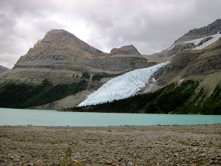
The berg glacier above berg lake
Crossing the lower section of the robson glacier with the extinguisher tower being the obvious feature in the background
The mighty emperor face
more of berg lake
below the robson glacier
Dinner in the tent
huge icefall on the robson glacier
Looking into the crevasses on the robson glacier
more glacier travel
Walking across the glacier on our retreat
looking back with Respendent in the background
the emperor face
the Emperor ridge
Looking at the skyladder route from further back
The bergshrund with the skyladder above
Looking down
Ian further down the face
Ian starting his lead up the last part of the face
Looking down at the athabasca glacier...can you spot the snow coach road
On the summit plateau with the summit being the high point in the background
The final summit ridge
Ian following
Ian on the summit
The NW shoulder direct route in the background...a future objective
Coming down the east ridge with some gnarly cornice buildup in the background
Ian on rappel
more rappelling with the AA col at the bottom of the photo
Ian crossing steep slopes under a huge cornice
Ian rappelling towards the bergshrund
The AA glacier
Looking back you can see the slope we descended being the shortest snow slope left of centre and the first of the three practice gullies right of centre


